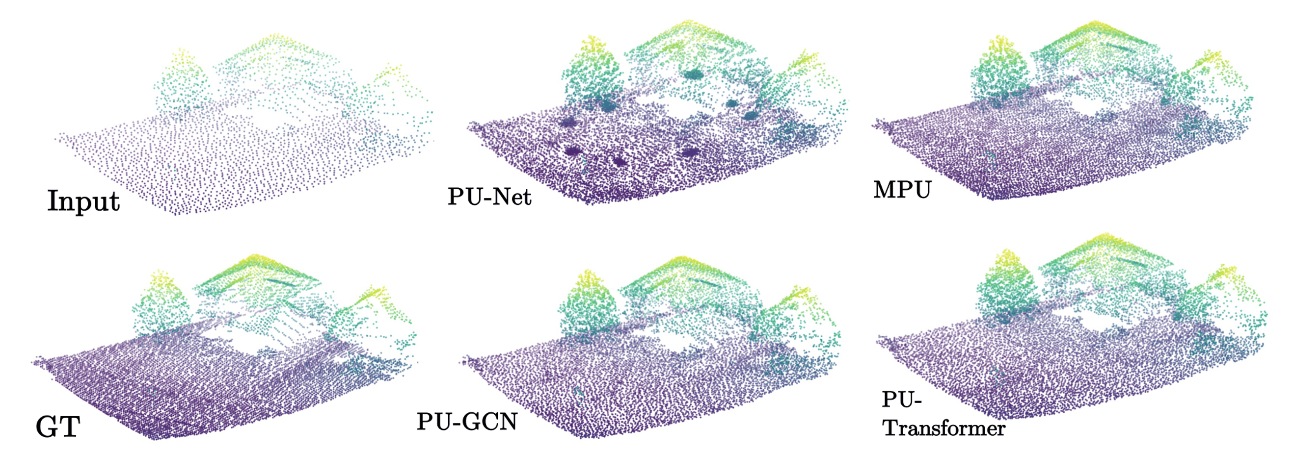
Qualitative comparison of upsampling outputs.

Comparative Evaluation of Point Cloud Upsampling Networks for Real-World LiDAR Terrain Reconstruction

Abstract Airborne LiDAR point clouds represent terrain but are often sparse, noisy, and unevenly distributed, limiting their use in surface reconstruction and geospatial analysis. This study benchmarks four learning-based point cloud upsampling architectures, PU-Net, MPU, PU-GCN, and PU-Transformer, using real-world terrain data from the U.S. Geological Survey 3D Elevation Program (3DEP). A unified Farthest Point Sampling (FPS)-based preprocessing pipeline generates input and ground-truth patch pairs. Each model is trained with a fixed 4× upsampling ratio and input patch sizes of 128, 256, 512, and 1024 points. Performance is assessed on a held-out terrain sub-region using Chamfer Distance, Hausdorff Distance, Point-to-Surface Distance, Earth Mover’s Distance, and the Normalized Uniformity Coefficient. MPU achieves the best mean surface fidelity and point uniformity, obtaining the lowest Chamfer Distance, Point-to-Surface Distance, and Normalized Uniformity Coefficient at 1024 input points. PU-GCN achieves the lowest Hausdorff Distance and Earth Mover’s Distance at 512 input points. PU-Transformer remains competitive, whereas PU-Net produces consistently larger errors and does not benefit reliably from denser inputs. The three more recent architectures generally improve as patch capacity increases, indicating that richer local context improves terrain reconstruction. Overall, MPU and PU-GCN are the most suitable approaches for real-world LiDAR terrain point cloud upsampling tasks. ...
August 2026 · Kittipong Tapyou, Taweechai Nuntawisuttiwong, Wongsatorn Sungsilapawech
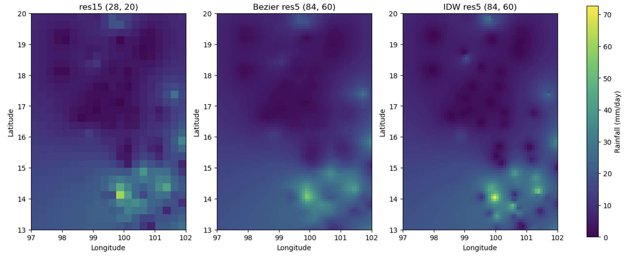
: Bézier upsampling for 27 September 2020. Left: Res15 input field (28×20 cells). Centre: Bézier -upsampled output at Res5 (84×60 cells). Right: directly interpolated IDW reference field at Res5 (84×60 cells). All panels use the same colour scale (mm day(_^(-1))

Patch-Based Bézier Surface Upsampling of Gridded Rainfall Data in the Chao Phraya River Basin, Thailand

Abstract High-resolution rainfall data are essential for basin-scale hydrological analysis, but long-term rainfall products are often available only at coarse spatial resolutions. This study proposes a patch-based upsampling method using Bézier surfaces to enhance the spatial resolution of gridded rainfall data over the Chao Phraya River Basin, Thailand. Daily rainfall observations from 79 Thai Meteorological Department stations during 1981 – 2021 were quality controlled and interpolated using Inverse Distance Weighting (IDW) to generate 15-arc-minute rainfall grids. Each coarse grid was subdivided into rectangular patches based on local rainfall peak locations. A tensor-product Bézier surface was fitted to each patch and sampled to produce a 5-arc-minute rainfall field. The proposed method was evaluated using spatial comparisons and monthly basin-average rainfall over the Chao Phraya River Basin. The upsampled fields preserved the broad spatial rainfall pattern of the coarse input while providing smoother rainfall gradients at the target resolution. Monthly basin-average rainfall from the Bézier -upsampled fields showed near-perfect agreement with the directly interpolated 5-arc-minute IDW reference field, with R^2=0.999 for 1981 – 2021. Strong agreement was also obtained with the T12 dataset (R^2=0.981) and K10 dataset (R^2=0.844), whereas agreement with the Thiessen polygon dataset was moderate (R^2=0.663). The results ...

August 2026 · Taweechai Nuntawisuttiwong, Wongnarin Kompor, Kittipong Tapyou, Poomipat Apiwattanaphong, Wirachat Thonguthaisri
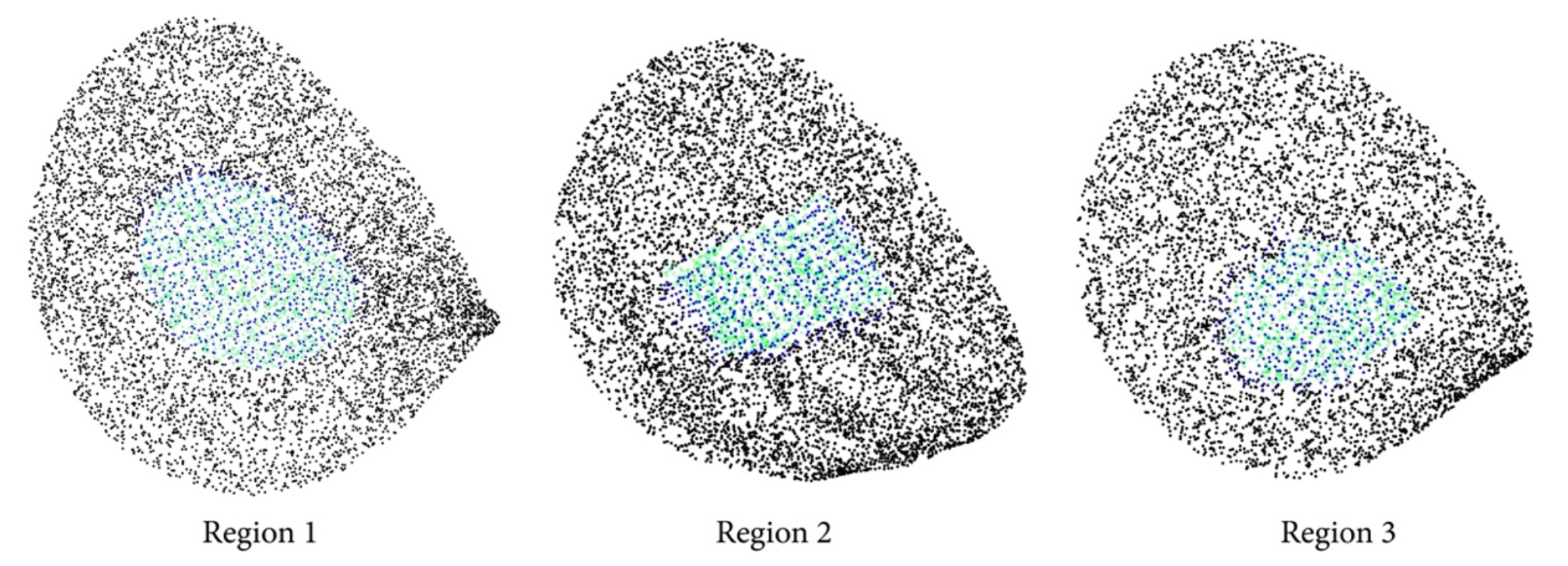
Detailed representation of points filling the reconstructed region.

Hole Filling for 3D Point Clouds via Bézier Curve with C1-Continuity Generation

Abstract Point cloud data, widely utilized in diverse applications such as autonomous navigation, heritage preservation, and geospatial modeling, frequently suffers from incompleteness due to occlusions, reflective surfaces, and limited sensor viewpoints. This incompleteness significantly impacts downstream tasks like classification, segmentation, and accurate surface reconstruction. To address this challenge, this paper presents a method for filling missing regions in point cloud data using cubic Bézier curves explicitly constrained by c1 continuity. The proposed technique identifies principal directions of data variance to partition the incomplete point cloud into manageable segments through a 3D slicing approach, facilitating efficient and localized control-point computation and curve fitting. Experimental evaluation demonstrates the high accuracy and geometric fidelity of the reconstructed surfaces, quantified by minimal Euclidean distance errors compared to ground truth data. These results confirm the robustness and effectiveness of the proposed Bézier-based reconstruction approach, providing smooth, structurally coherent, and visually consistent surfaces ...

November 2025 · Taweechai Nuntawisuttiwong, Kittipong Tapyou, Wongsatorn Sungsilapawech
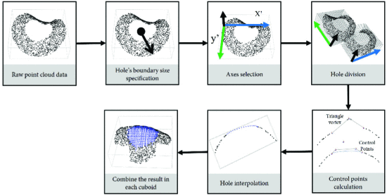
Overall methodology

A Novel Triangulation-Based Method for Hole Filling in 3D Point Clouds Using Approximation Curve Fitting

Abstract In point cloud data processing, preprocessing is a critical step, particularly for addressing incomplete data caused by occlusions or limited visibility during acquisition. To enhance the completeness of point cloud models, this paper proposes a method for reconstructing missing regions using approximation curves. The approach begins by deriving control points from the existing point cloud, which are used to construct curves that closely conform to the surface geometry. Control points are computed through triangulation and spatial analysis, ensuring that the generated curves align with the local structure of the data. Uniform sampling is then applied along each curve to produce a set of points that effectively fill the missing regions. Experimental results demonstrate that the proposed method can successfully reconstruct surface segments with consistent spacing and high accuracy, making the data suitable for downstream applications such as 3D modeling, object classification, and structural analysis. ...

October 2025 · Taweechai Nuntawisuttiwong, Kittipong Tapyou, Wongsatorn Sungsilapawech, Natasha Dejdumrong
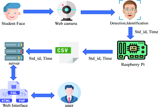
System diagram

Smart School Attendance System using Face Recognition with Near Optimal Imaging

Abstract This work aimed to develop a students’ school attendance system with a web application and IoT devices as the two main parts. The web application was designed to manipulate the student data acquisition while IoT was used for face recognition to detect student attendance. This process applied Haar cascade and EBGM approaches to classify and distinguish faces for the web application. The web application was implemented with PHP language and a MySQL database provided for usage by three user groups: teachers, students and staff. The face recognition system was implemented on Raspberry Pi to connect with web application and record the student time attendance data. This work improves the accuracy of face detection by use of physical factors. We found that the current face recognition algorithm is highly efficient if the face position is arranged for clear image capture. Thus, this work also focuses on finding the right position to capture the user’s face. The experimental test provided 100% accuracy of student classifier when they stand in a suitable position for imaging. The results show that the suitable position depends on the student face training count. In addition, the distance between camera and standing student affects the accuracy of face recognition. ...

July 2021 · Kittipong Tapyou, Pannawich Chaisil, Jirapond Muangprathub